

Location and Transport
The National Rehabilitation Hospital is located in South County Dublin on Rochestown Avenue near the town of Dún Laoghaire. Eircode: A96 RPN4
Car Parking
Car Parking is available in the hospital grounds. Hospital Management cannot accept responsibility for loss or damage to your property while on the hospital grounds.
Authorised parking areas and speed limits on the hospital grounds are clearly marked; visitors to the NRH are asked to adhere to these for their safety and the safety of others.
Directions to the National Rehabilitation Hospital
From Junction 14 on the M50
- When travelling south on the M50, exit at Junction 14, take 2nd exit onto R113.
- At the next roundabout, just after the Hotel, take the 3rd exit on to Leopardstown Road.
- Continue to junction with dual carriageway traffic lights and turn right onto N11 – Stillorgan Road. (Direction south to Wexford).
- Take next left at Foxrock Church onto Kill Lane – R830. Continue straight on R830 crossing the main junction at Deansgrange Road – at this junction you will see a row of shops to your right, and a public house to the left.
- Continue on towards the next main junction, moving into the lane for turning right before reaching the traffic lights.
- At the traffic lights turn right at Baker’s Corner public house onto Rochestown Avenue.
- Continue on Rochestown Avenue to first set of traffic lights and keep left at Junction with Pottery Road. The NRH is 1km on your right hand side.
* Please Note: Major Roadworks underway at Bakers Corner Junction leading on to Rochestown Avenue
The Dún Laoghaire Central Active Travel Scheme has commenced a major project to 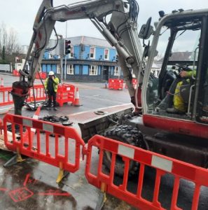 upgrade existing local traffic, pedestrian and cycle infrastructure to enhance safety for people of all ages and abilities.
The first phase of work, which is being undertaken at the Bakers Corner junction, commenced on 5th February and will continue for approximately 3 months.
DLRCC have advised that while works are ongoing there will be significant disruption at Bakers Corner junction and have advised that members of the public should, where possible, take alternative routes to avoid the area.
Further updates are available on the DLRCC Website here.
From Junction 16 on the M50
- When travelling north on the M50 exit at Junction 16 onto R118.
- Take 2nd exit at roundabout and continue straight crossing flyover above N11 onto Wyattville Road, following signs for R118 towards Sallynoggin.
- Continue on to Church Road, passing St. Matthias’ Church on your left, until next roundabout.
- Take 1st exit at roundabout on to R828 (towards Blackrock); you are now on Rochestown Avenue, with the Killiney Shopping Centre on your right hand side. The NRH is approximately 1.5km further ahead on the left hand side.
Public Transport Links
Bus Routes
For bus route information and timetables, please visit www.dublinbus.ie.
Please note that some bus routes may leave you a considerable distance from the NRH entrance. Other routes service the hospital less frequently. Please check with Dublin Bus for details.
Train and DART Services
For train and DART timetables please visit: www.iarnrodeireann.ie or www.irishrail.ie
Taxi Service
A Taxi Service is available in Dún Laoghaire. The Taxi Rank is on Marine Road, opposite the shopping centre and 200 yards from the Railway and DART Station.